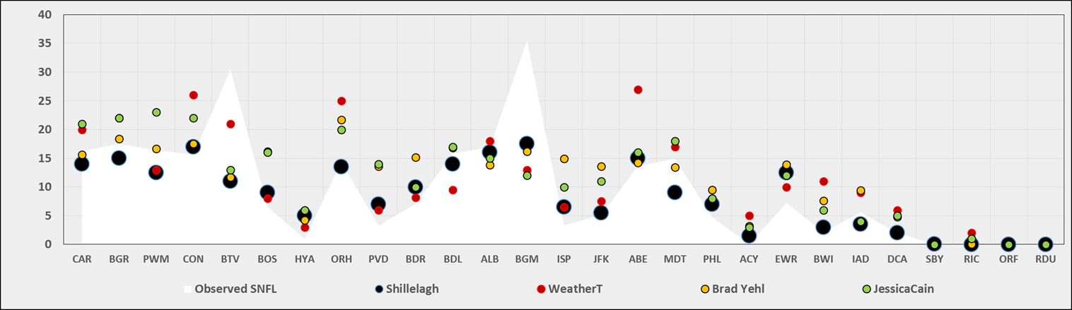
Complete Results @ http://www.newx-forecasts.com/
Follow the left-side link from 'Storm-total Contest Verified Forecasts’ – Contest #4 to see the complete station forecast verification table.
In the table...
Yellow cells indicate the best score in category.
Forecast STP cells are yellow if within +/- 5% of observed STP.
Blue (Red) cells indicate the top (lower) 25% percentile.
SUMSQ: sum of square errors
STP: storm total precipitation
TAE: total absolute
error
AAE: average absolute error
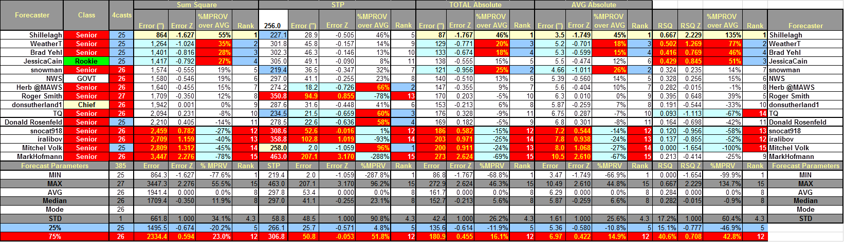
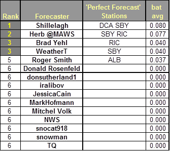
Final Standings - all Forecasters
Perfect Forecasts
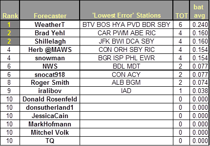
Best Station Forecasts (Batting Average - Percentage of Forecast Stations with Lowest Absolute Error)
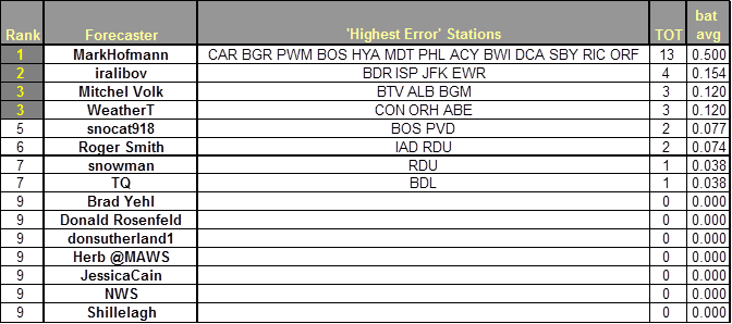
Best Station Forecast Busts (Batting Average - Percentage of Forecast Stations with Highest Absolute Error)
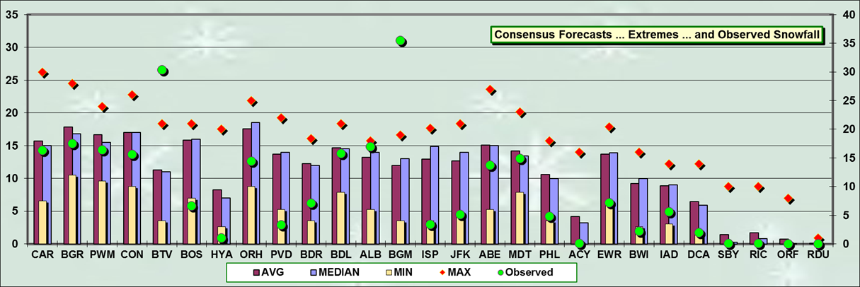
Consensus forecast best @ CAR … BDL … ALB … MDT
MAX forecast best @ BTV … ALB … BGM
MAX forecast less than observed @ BTV … BGM
MIN forecasts best @ BOS … HYA … PVD … BDR … ISP … JFK … PHL … ACY … EWR … BWI … IAD … DCA
MIN forecasts more than observed @ BOS … HYA … PVD … EWR … BW … DCA
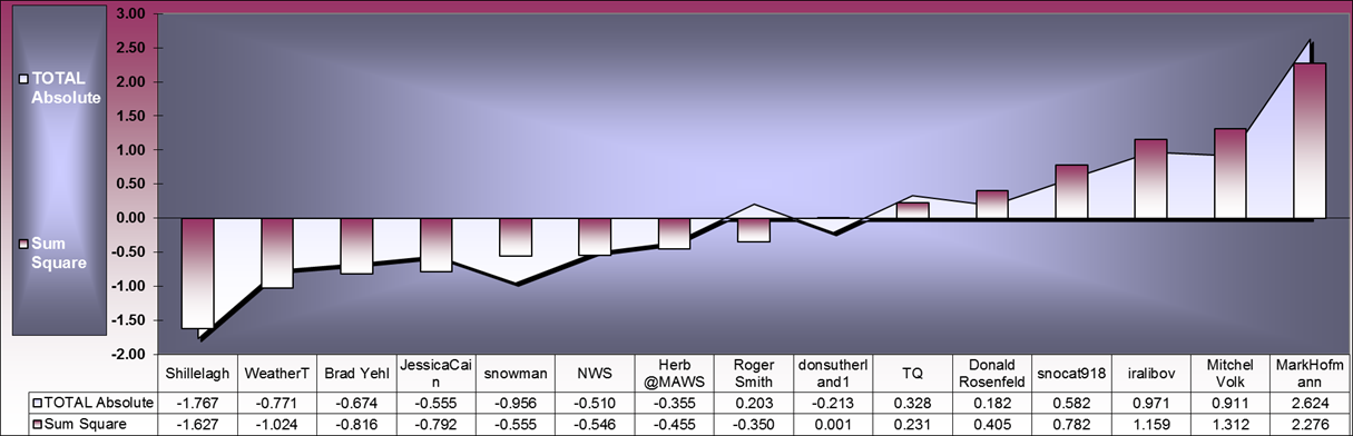
Fair association between SUMSQ and TAE Z-scores
*******************************
Verification:
Good data from CDUS41 … PNS … and F6 bulletins.
Exceptions:
HYA
Storm-total snowfall report from PNSBOX.
SBY and RIC
Trace amounts based on METAR reports of PL
Stations observing at least:
Trace - 25
4" - 17
6" - 14
8" - 11
10" - 11
12" - 11
15" - 6
18" - 2
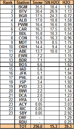
Max melt-water at BGM (1.93")
Other stations with at least 0.99" melt-water:
MDT (1.75")
ALB (1.58")
ORH (1.54")
BDL (1.54")
ABE (1.37")
BTV (1.13")
PWM (0.99")
Snow-Liquid Ratios (SLR) at forecast stations with mixed precipitation ... such as ISP and JFK ... are not reported.
---
15 New Daily
Records:
14-MAR-7
BGM - 31.2" (5.9"; 1991)
BTV - 17.8" (10"; 1980)
ALB - 17" (12.9"; 1958)
PWM - 16.3" (10.6"; 1961)
CON - 15.6" (6.6"; 1984)
MDT - 14.7" (8.3"; 1999)
ORH - 14.4" (11.5"; 1958)
ABE - 12.4" (8.4"; 1958)
BDR - 7.1" (3"; 1958)
EWR - 7" (4.6"; 1958)
BOS - 6.6" (3.8"; 1942)
JFK - 5.1" (2.1"; 1999)
IAD - 4.1" (4"; 1999)
ISP - 3.4" (2"; 1999)
15-MAR-17
BTV - 12.6" (4.1"; 1940)
Blizzard or near-blizzard obs (these are the only NWS/FAA observing stations reporting blizzard conditions.
Puts to rest the idiotic notion AWOS cannot measure visibilities < 1/4SM)
Monticello, NY
KMSV 141635Z AUTO 31008KT 1/4SM VV002 M04/M05 A2948 RMK AO1
KMSV 141615Z AUTO 01006G18KT M1/4SM VV000 M04/M05 A2949 RMK AO1
KMSV 141555Z AUTO 01010G30KT M1/4SM VV000 M04/M05 A2949 RMK AO1
KMSV 141535Z AUTO 04014G36KT M1/4SM VV000 M05/M06 A2952 RMK AO1
KMSV 141515Z AUTO 06026G38KT 1/4SM VV002 M05/M06 A2956 RMK AO1
KMSV 141455Z AUTO 06030G53KT 1/4SM VV002 M04/M06 A2963 RMK AO1 P0219 60219 57071
KMSV 141435Z AUTO 09029G38KT M1/4SM BKN002 M04/M06 A2964 RMK AO1
KMSV 141415Z AUTO 02004KT M1/4SM VV000 M05/M06 A2965 RMK AO1
Oxford, Connecticut
KOXC 141555Z AUTO 05021G41KT 1/4SM OVC004 M02/M05 A2938 RMK AO1
KOXC 141535Z AUTO 05022G39KT M1/4SM OVC003 M03/M05 A2940 RMK AO1
KOXC 141515Z AUTO 05026G42KT M1/4SM OVC003 M03/M06 A2945 RMK AO1
KOXC 141455Z AUTO 05023G36KT M1/4SM OVC003 M03/M07 A2951 RMK AO1 57115
KOXC 141435Z AUTO 05016G34KT M1/4SM OVC002 M03/M06 A2960 RMK AO1
KOXC 141415Z AUTO 05019G32KT M1/4SM OVC003 M04/M07 A2964 RMK AO1
KOXC 141355Z AUTO 05021G35KT M1/4SM OVC004 M04/M07 A2969 RMK AO1
KOXC 141335Z AUTO 06020G29KT 020V080 M1/4SM OVC005 M04/M07 A2974 RMK AO1
Lawrence, MA (near blizzard; duration failure)
KLWM 141754Z 06029G44KT 1/4SM +SN FG VV004 01/00 RMK AO2 PK WND 04044/1748 SLPNO P0010 60019 T00060000 10006 21028 $
KLWM 141700Z 06027G36KT M1/4SM +SN FG VV003 00/M01 A2971
KLWM 141654Z 06027G36KT M1/4SM +SN FG VV003 00/M01 RMK AO2 PK WND 05039/1635 SLPNO P0007 T00001006 $
KLWM 141610Z 06024G35KT M1/4SM +SN FG VV004 00/M01 RMK AO2 PK WND 04038/1558 P0002 T00001006 $
Portsmouth, NH
KPSM 142015Z 05029G40KT 1/4SM R34/3500FT SN BLSN OVC001 00/M00 A2931 RMK AO2A PRESFR
KPSM 141958Z 04028G42KT 1/8SM R34/3000FT SN BLSN BKN001 OVC005 00/M01 A2935 RMK AO2A PK WND 03050/12 PRESFR SLP942 P0007 T00041006
KPSM 141858Z 05025G36KT 1/8SM R34/2400FT SN BLSN BKN001 OVC005 00/M01 A2949 RMK AO2A PK WND 06044/31 SLP990 P0007 T00031007
KPSM 141758Z 04023G34KT 1/8SM R34/1600FT +SN BLSN VV002 M00/M01 A2964 RMK AO2A PK WND 05040/35 PRESFR SLP040 P0010 60034 4/004 T10011010 11000 21038 57125
KPSM 141658Z 06022G38KT 1/8SM R34/2000FT +SN BLSN VV002 M00/M01 A2978 RMK AO2A PK WND 05039/43 PRESFR SLP088 P0010 T10041014
Concord, NH
KCON 142051Z AUTO 04017G30KT 1/4SM SN FZFG VV006 M03/M06 A2929 RMK AO2 PK WND 04031/2021 SLP922 P0010 60032 T10331056 56122
KCON 142040Z AUTO 04012G30KT 1/4SM SN FZFG VV005 M04/M06 A2929 RMK AO2 PK WND 04031/2021 PRESFR P0008 T10391056
KCON 141951Z AUTO 04017G32KT M1/4SM +SN FZFG VV003 M04/M06 A2940 RMK AO2 PK WND 04035/1903 SLP961 P0014 T10391056
KCON 141902Z AUTO 04024G32KT M1/4SM +SN FZFG VV002 M04/M06 A2949 RMK AO2 PK WND 04032/1902 PRESFR P0003 T10391056
KCON 141851Z AUTO 05019G28KT M1/4SM +SN FZFG VV003 M04/M06 A2952 RMK AO2 PK WND 05036/1834 PRESFR SLP002 P0008 T10391056
KCON 141751Z AUTO 05017G31KT M1/4SM +SN FZFG VV003 M03/M05 A2965 RMK AO2 PK WND 04031/1749 PRESFR SLP046 P0008 60033 T10331050 11033 21050 58126
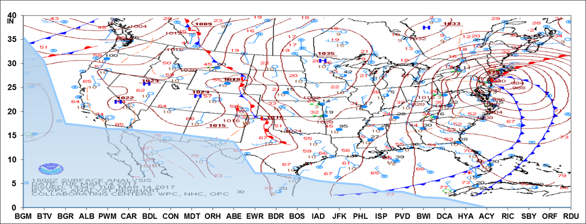
NY Harbor (40.6 mb 12-hour pressure fall ending 18z 14-MAR)
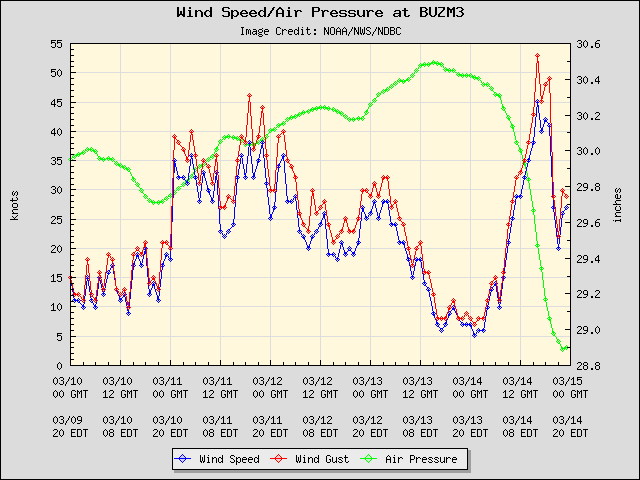
Buzzards Bay, MA (47.4 mb 12-hour pressure fall ending 21z 14-MAR)