9th Annual
NE.Weather
Snowfall Forecast Contest

Winter '07 / '08

FINAL Standings


7th Annual
Season-total Contest
Verified Forecasts
Results Summary

Contest Announcements and Updates on the BLOG


'07 / '08 Storm Contest Winner
Don Sutherland

'07 / '08 Season-total Contest Winner
Duke kc2dux

Past Contest Winners

Arctic
Oscillation
North Atlantic
Oscillation


NESDIS SN Cover
Analysis

US SN Depth


NHEMI SN Depth


National
SN Analysis

Updated:  4 April 2008 @ 2230 EDT

DATA


Forecast Station List by State

(linked to verifying CF6)

ME

NH

VT

MA

RI

CT

NY

PA

NJ

MD

VA

NC

CAR
Caribou

CON
Concord

BTV
Burlington

BOS
Boston

PVD
Providence

BDR
Bridgeport

ALB
Albany

ABE
Allentown

ACY
Atlantic City

BWI
Baltimore

IAD
Dulles

RDU
Raleigh

BGR
Bangor

    HYA
Hyannis
  BDL
Hartford
BGM
Binghamton
MDT
Harrisburg
EWR
Newark
DCA
Washington
ORF
Norfolk
 

PWM
Portland

    ORH
Worcester
   

ISP
Islip

PHL
Philly


SBY
Salisbury

RIC
Richmond


JFK
Kennedy AP


Contest
Rules


Forecast
Stations


There are 27 permanent stations for each event. Station locations range
from Raleigh...NC (RDU) to Caribou...ME (CAR).

Here/s a map showing their locations (courtesy Steve Okonski).


Who
Can
Enter
?


Amateur and professional forecasters; broadcasters with or without trained
Seals; all weather-biz types and wanna-bees; wish-casters...astrologers and
other commonly recognized classes of dreamers; Pollyannas or Cassandras...
registered Nostradamists...non-violent megalomaniacs...woolly-bear caterpillars
or their agents; pest detectives...NE.Wx NG regulars and lurkers; refugees from
EUSWx and/or StormVista...and of course... meteorologists.

Trolls...goats...hat3-lsiters...and psests need not apply.


Entries


Enter your forecasts on the Forecast Entry page.

If you/re a first-time forecaster...you can create an account if you have
an e-mail address and can come up with a user name and password.

Your account is password protected.  Please ensure your browser is enabled
to accept first-party cookies.

After you submit your forecast...a copy of it will be e-mailed to you.

All forecasts will be posted automatically to the NE.Wx Google Group within
30 minutes after the entry deadline has passed.

New contest announcements are made on the NE.Wx Google Group...the
NEWxSFC web log...'StormVista'...'The Golden Snowball'...and via
e-mail by the Contest Administrator ~24 hours in advance of the deadline.

In most cases...the deadline is 10:30 PM EST.

The Contest Administrator reserves the right to reject any forecast that might
compromise the integrity of the contest.


Forecast
Snowfall
Amounts


MIN value: 0"
MAX value: 99"
MAX decimal places: 2

If a trace snowfall is expected at a station...please enter 0.05".


Verification

Forecasts are verified against each station/s storm-total snowfall (STP)...
as reported by NWS Preliminary Local Climatological Bulletins (CF6).

In the event a CF6 is not available or appears to contain errors...the
following sources...listed in order of preference...will be used:  CDUS41...
PNS...and METAR.

STP reports are posted to the NEWxSFC web log prior to forecast verification.
The reports are considered preliminary and subject to change / challenge for
24 hours...if updated information becomes available.


Scoring


The scoring system is designed to determine objectively which forecast had
the best overall synoptic quality.  An accurate...high-quality...synoptic-scale
snowfall forecast is defined as one that best captures the magnitude and
distribution of the storm/s total snowfall.  Forecast quality is evaluated by
calculating its 'goodness of fit' between all forecast and observed snowfall
amounts.

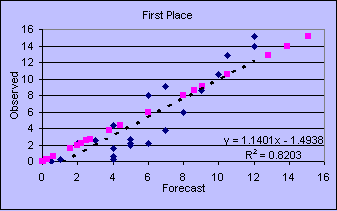
The scatter plot/s black diamonds show the forecast snowfall (x-axis) plotted
against the observed snowfall (y-axis).  The dashed line represents the
forecast/s 'goodness of fit.' The magenta points represent a perfect
forecast...where each station forecast matched each station observation.

The R² value indicates the forecast accounted for 82% of the variability
between forecast and observed snowfall amounts. A 'perfect' forecast would
have an R² value of 1...meaning 100% of the observed snowfall/s variability
as accounted for by the forecast.


The forecast error statistic is the Sum of Squared Errors (SUMSQ).

The difference between the Forecast and Observed snowfall at each station is
squared and the squared errors for all stations are summed. This skill measure
rewards (penalizes) station forecasts with small (large) errors.

The smaller the SUMSQ...the better the synoptic-scale forecast.

If the difference between your Forecast snowfall and the Observed snowfall is:
one-inch = one error point
two-inches = four error points
three-inches = nine error points


Each forecaster/s SUMSQ Error score is normalized to a Z-Score for use in
calculating Interim and End-of-Season standings.

Forecasts with normalized Z-scores greater than or equal to 2.5 standard
deviations above the mean are subject to exclusion as outliers.

If Snow is Observed and Snow is Not Forecast...
then the Forecaster/s Snowfall Amount is set to '0' for that station.

If Snow is Forecast and Snow is Not Observed...
then the Observed Snowfall Amount is set to '0' for that station.

If Snow is not Forecast and Snow is Not Observed...
then the Forecaster is not scored for that station.


Other forecast statistics are reported...such as average absolute error (AAE)
...total absolute error (TAE)...total snowfall error (STP)...R²...and
'batting averages'...but these 'measures of skill' do not factor into forecast
rankings.


Results


Full forecast verification and summary results are posted on the Contest
web page.

Abbreviated results are posted to NEWxSFC/s web log...NE.Wx Google Group
and 'StormVista.'


End-of-the-Season
Final Standings


The Contest winner is determined by which Forecaster has the lowest average
Sum of Square Error (SUMSQ) Z-Score at the end of the season.

Forecasters must participate in at least two-thirds (2/3) of all Storm Contests
to be eligible for ranking in the Final Standings.

Forecasters who have participated in at least two-thirds (2/3) of all Storm
Contests will have Z-scores from their 'best two-thirds' forecasts used to
calculate the interim and final standings. The intent of this rule is to encourage
forecasters to 'take on' difficult and/or late-season storms without fear of
jeopardizing their score b/c of a 'bad' forecast.


Prizes


The top-ranked 'Snow Storm' Forecaster receives the book...
New England Weather New England Climate...
by Gregory Zielinski and Barry Keim and
one month of free access to StormVista GOLD

The top-ranked 'Season-total snowfall' Forecaster receives...
"The Snow Booklet"...by Nolan J. Doesken and Arthur Judson


Disputes


The contests are intended to be easy and fun to play.
Disputes are not easy nor fun.

Errors can and do happen.  Please report them...and a link to the correct
data to Contest Administrator.

Replace 'ATAT' in the address with '@.'


Hit Counter